Property Record
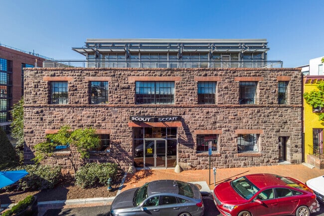
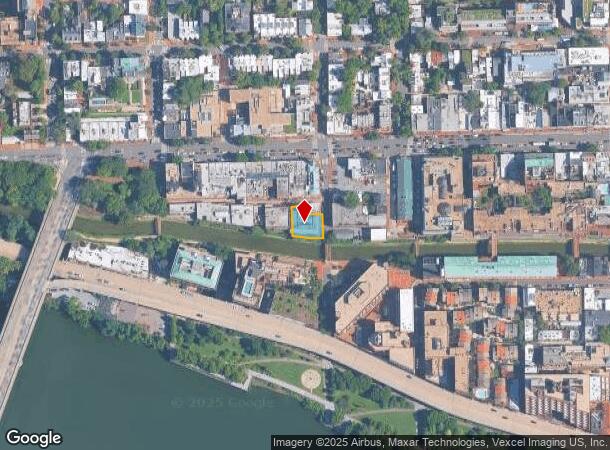
1028 33Rd St Nw, Washington, DC 20007


NEARBY LISTINGS FOR SALE OR LEASE
Property Detail
1028 33Rd St Nw
Washington-Arlington-Alexandria, DC-VA-MD-WV
Georgetown
1184-0047
SQUARE 1184 LOT 0047 NBHD: GEORGETOWN
Officebuilding
District of Columbia
X
District of Columbia
51013C0039D
47
2025
0.17 AC
2025
Georgetown
000202
Washington, DC
15,618 SF
DEMOGRAPHICS near 1028 33Rd St Nw
1 Mile
3 Mile
5 Mile
2024 Total Population
37,361
318,609
752,184
2029 Population
35,365
296,782
708,089
Pop Growth 2024-2029
(5.34%)
(6.85%)
(5.86%)
Average Age
37
37
38
2024 Total Households
19,315
165,048
355,682
HH Growth 2024-2029
(6.21%)
(7.59%)
(6.46%)
Median Household Inc
$113,591
$120,536
$117,323
Avg Household Size
1.70
1.80
2.00
2024 Avg HH Vehicles
1.00
1.00
1.00
Median Home Value
$967,658
$817,894
$796,281
Median Year Built
1971
1966
1964
Nearby Places
Map Layers
Map Styles
 Street
 Aerial
- Restaurants
- Banks
- Shops
- Fitness
- Groceries
PUBLIC TRANSPORTATION
TRANSIT/SUBWAY
Rosslyn (Blue Line - Washington Metropolitan Area Transit Authority Metrorail (Metrorail), Orange Line - Washington Metropolitan Area Transit Authority Metrorail (Metrorail), Silver Line - Washington Metropolitan Area Transit Authority Metrorail (Metrorail))
DRIVE
WALK
Distance
Rosslyn (Blue Line - Washington Metropolitan Area Transit Authority Metrorail (Metrorail), Orange Line - Washington Metropolitan Area Transit Authority Metrorail (Metrorail), Silver Line - Washington Metropolitan Area Transit Authority Metrorail (Metrorail))
5 min
16 min
0.9 mi
Foggy Bottom-GWU (Blue Line - Washington Metropolitan Area Transit Authority Metrorail (Metrorail), Orange Line - Washington Metropolitan Area Transit Authority Metrorail (Metrorail), Silver Line - Washington Metropolitan Area Transit Authority Metrorail (Metrorail))
DRIVE
WALK
Distance
Foggy Bottom-GWU (Blue Line - Washington Metropolitan Area Transit Authority Metrorail (Metrorail), Orange Line - Washington Metropolitan Area Transit Authority Metrorail (Metrorail), Silver Line - Washington Metropolitan Area Transit Authority Metrorail (Metrorail))
4 min
19 min
1.0 mi
COMMUTER RAIL
Union Station (Brunswick Line - Maryland Area Regional Commuter Trains (The MARC), Camden Line - Maryland Area Regional Commuter Trains (The MARC), Penn Line - Maryland Area Regional Commuter Trains (The MARC))
DRIVE
WALK
Distance
Union Station (Brunswick Line - Maryland Area Regional Commuter Trains (The MARC), Camden Line - Maryland Area Regional Commuter Trains (The MARC), Penn Line - Maryland Area Regional Commuter Trains (The MARC))
16 min
3.6 mi
Crystal City (Fredericksburg Line - Virginia Railway Express, Manassas Line - Virginia Railway Express)
DRIVE
WALK
Distance
Crystal City (Fredericksburg Line - Virginia Railway Express, Manassas Line - Virginia Railway Express)
9 min
4.1 mi
AIRPORT
Ronald Reagan Washington Ntl
DRIVE
WALK
Distance
Ronald Reagan Washington Ntl
12 min
5.0 mi
Washington Dulles International
DRIVE
WALK
Distance
Washington Dulles International
28 min
24.5 mi
Baltimore/Washington International Thurgood Marshall
DRIVE
WALK
Distance
Baltimore/Washington International Thurgood Marshall
45 min
38.3 mi
SALE & LEASE HISTORY
LISTING DATE
SALE/LEASE

Mar 01, 2019
For Lease
Jul 13, 2023
For Lease
Nearby Properties
Address
Land Use
TOTAL SIZE
Lot Size
Zoning
Address
Land Use
TOTAL SIZE
Lot Size
Zoning
2,300,000 SF
1.60 AC
D-5-R
Address
Land Use
TOTAL SIZE
Lot Size
Zoning
2,052,109 SF
90.60 AC
UNZONED
Address
Land Use
TOTAL SIZE
Lot Size
Zoning
128,439 SF
373.22 AC
UNZONED
Address
Land Use
TOTAL SIZE
Lot Size
Zoning
533,778 SF
18.08 AC
UNZONED
Address
Land Use
TOTAL SIZE
Lot Size
Zoning
5,483 SF
88.76 AC
GOV
Address
Land Use
TOTAL SIZE
Lot Size
Zoning
1,517,010 SF
70.25 AC
UNZONED
Address
Land Use
TOTAL SIZE
Lot Size
Zoning
142 AC
GOV
Address
Land Use
TOTAL SIZE
Lot Size
Zoning
2,493,936 SF
8.99 AC
UNZONED
Address
Land Use
TOTAL SIZE
Lot Size
Zoning
3.71 AC
UNZONED
Address
Land Use
TOTAL SIZE
Lot Size
Zoning
63.89 AC
GOV
Address
Land Use
TOTAL SIZE
Lot Size
Zoning
3,750,395 SF
10.82 AC
UNZONED
Address
Land Use
TOTAL SIZE
Lot Size
Zoning
262,673 SF
5.35 AC
D-7
Address
Land Use
TOTAL SIZE
Lot Size
Zoning
1,530,865 SF
6.05 AC
D-6;UNZONE
Address
Land Use
TOTAL SIZE
Lot Size
Zoning
6,500,000 SF
92.03 AC
S-3A
Address
Land Use
TOTAL SIZE
Lot Size
Zoning
42.57 AC
GOV
Address
Land Use
TOTAL SIZE
Lot Size
Zoning
2,455,000 SF
11.08 AC
MU-2
Address
Land Use
TOTAL SIZE
Lot Size
Zoning
52.44 AC
UNZONED
Address
Land Use
TOTAL SIZE
Lot Size
Zoning
1,100,000 SF
2.13 AC
D-6
Address
Land Use
TOTAL SIZE
Lot Size
Zoning
1,310,661 SF
3.38 AC
D-6
Address
Land Use
TOTAL SIZE
Lot Size
Zoning
1,336,013 SF
5.41 AC
D-5
Address
Land Use
TOTAL SIZE
Lot Size
Zoning
1,738,573 SF
2.11 AC
D-7
Address
Land Use
TOTAL SIZE
Lot Size
Zoning
1,081,367 SF
6.46 AC
UNZONED
Address
Land Use
TOTAL SIZE
Lot Size
Zoning
1.57 AC
D-5
Address
Land Use
TOTAL SIZE
Lot Size
Zoning
1,015,833 SF
1.60 AC
D-7
Address
Land Use
TOTAL SIZE
Lot Size
Zoning
2,247,684 SF
6.39 AC
D-4-R
Address
Land Use
TOTAL SIZE
Lot Size
Zoning
553,914 SF
55.91 AC
R-1B
Address
Land Use
TOTAL SIZE
Lot Size
Zoning
758,000 SF
2.22 AC
D-4-R;MU-7
Address
Land Use
TOTAL SIZE
Lot Size
Zoning
1,185,122 SF
2.43 AC
D-6
Address
Land Use
TOTAL SIZE
Lot Size
Zoning
4.95 AC
UNZONED
Address
Land Use
TOTAL SIZE
Lot Size
Zoning
1,562,988 SF
15.33 AC
MU-10 (IZ+
The World's #1 Commercial Real Estate Marketplace
Connect with us
© 2025 CoStar Group
The information above has been obtained from sources believed reliable. While we do not doubt its accuracy we have not verified it and make no guarantee, warranty or representation about it. It is your responsibility to independently confirm its accuracy and completeness. Any projections, opinions, assumptions, or estimates used are for example only and do not represent the current or future performance of the property. The value of this transaction to you depends on tax and other factors which should be evaluated by your tax, financial, and legal advisors. You and your advisors should conduct a careful, independent investigation of the property to determine to your satisfaction the suitability of the property for your needs.